by Jonathan Kreiss-Tomkins:
I have always been fascinated by the superlative. Fastest. Hardest. Longest. Highest. The –est has always captured my imagination and, in some way or another, often guided my actions. On the morning of January 2, it landed me on the side of a road in the Puna de Atacama, the mountainous frontier of the northern Chilean-Argentine Andes.
My climbing companion Chandler Kemp and I were here to climb a mountain—a superlative mountain—by the name of Ojos del Salado. Among the Puna’s many high peaks, Ojos del Salado rises above the rest. In fact, at approximately 22,600 feet, it stands second in South America only to Aconcagua, and by only a few dozen meters. And as a volcano, it stands second to none: Ojos is the tallest volcano in the world.
Ojos is a mountain of topographic coincidence. From its massif, two distinct summits of approximately equal altitude rise up, their peaks within a meter of each other. Complicating matters, while both summits technically straddle the Argentine-Chilean border, climbers ascend each one from different countries. The ruta argentina leads to the de facto Argentine summit, and the ruta chilena leads to the de facto Chilean summit. Since Ojos was first ascended in 1937, no one has known which of its two summits is the taller, “true” summit. That’s what we set out to discover.
***
The Puna de Atacama is one of the few places in the world where hitchhiking is a reliable mode of transport. Encompassing the northern Chilean-Argentine Andes and just south of the parched Atacama Desert of Bolivia, the Puna is dry, barren, windy, unpopulated, and rarely visited.
After waiting a little over an hour by the side of the road, a metallic glint flickered on the horizon through the shimmers of heat rising off the solitary asphalt road. We were in luck: a ride.
Sixty-five kilometers later, 25 kilometers short of the official Chilean border, we arrived at the small outpost of civilization that was Argentina’s border post. I hopped off the overstuffed bed of the pick-up and walked towards the cluster of Spartan military-hut architecture that we would call home for the next week. This youth hostel 13,000 feet in the Andes was built by the Province of Catamarca about a decade ago in a burst of entrepreneurial vigor meant to attract mountaineers. The province’s tourism enterprise has been a qualified success. Climbing in this region of the Andes has been on the uptick owing to both effective marketing of its extraordinarily high mountains and also the accommodations, minimalist as they might be, that make it accessible.

A handful of scraggly, sunburned climbers mingled in the shade of the huts. It felt vaguely like we were outsiders sauntering into an Old West frontier town, the locals peering out their saloon doors, sizing up the newcomers. But climbers are characteristically friendly people, and as we approached the squinted eyes warmed to smiles and outstretched hands. Looking over our new acquaintances, one tall, lithe climber in his mid-thirties immediately captured my attention. Of all places, a familiar face.
Alex Garate was the first climber I met when I first came to these mountains four years ago. I was 18 years old, drunk on ambition, and awash in romanticism for adventure, but Alex patiently counseled me as best anyone could before we went our separate ways into the hills. His first words of our reunion told how well he had come to know me: “A four year journey for you, Jonathan?”
***
The frontier implies something beyond what we know or what we are capable of. On many levels, the Puna had become my frontier these last four years, my place to engage the superlative. Once accounting for most of the world, frontiers have been systematically winnowed by civilization’s inexorable advance, restricted to a few far-flung regions. Terra incognita—the manifestation of a frontier—is now a concept as obsolete as the expression is archaic: The distant icy poles of the Arctic and Antarctic have been conquered, the forbidding summit of Everest achieved, the source of the Nile discovered.
Present-day discoveries are a bit like the reunion tour of an over-the-hill, once-great band: As exciting as they might be, you can’t help but think of what the golden age must have been like. Landsat Island is a perfect example. A frozen, unremarkable speck off the coast of Labrador about a fifth the size of a football field, it was found in 1973 when a Canadian scientist noticed it in a Landsat satellite image. The discovery ranks as one of the most significant in decades. Contemporary terra incognita is the mere technicality or happenstance of the unknown.
***
Chandler and I had ventured to the Puna de Atacama because it is a frontier, one of the last of its kind. We were out to find a Landsat Island of sorts, and we knew it was out there.
We had teamed up with Frederick Blume, a geophysicist from a consortium-chartered geodesy laboratory in Boulder, Colorado called UNAVCO. Blume was part of the 1997 and 1998 National Geographic expeditions to Mount Everest that determined its now-accepted altitude, and he knows all there is to know about measuring mountains. Trimble, a company that designs and manufactures GPS equipment, our means of measurement, signed on to generously provide the $30,000 of technical gear required for the expedition. And from my previous sorties to the Puna, I had built up an informal network of Argentine climbers, government officials, and scientists to assist with logistics. All the pieces were in place; we just needed to climb the darn thing.

Climbing a mountain like Ojos, however, begins with preparing the body. Altitude has a formidable effect and demands profound respect.
More than once I encountered a favorite hypothetical anecdote of South American climbers, the science of which I later corroborated with Dr. Peter Hackett, Director of the Institute for Altitude Medicine in Telluride, Colorado. Imagine someone living at sea level who contracts a helicopter to land him on the summit of Aconcagua or Ojos, an ascent of about 23,000 feet. No matter how delicately he might conserve his energy or how valiantly he might try to steady his breathing, the thin air will render him unconscious within hours and on the verge of death; such is the hypoxic shock of altitude. Were he to go all the way to 26,000 feet, the height of the tallest peaks of the Himalayas, he would be dead in 30 minutes. The moral is obvious: Ascend too fast, allow ambition to “helicopter” you up a mountain, and risk everything.
In my mind, altitude was a frontier of its own, a physiological frontier, and almost certainly the most dangerous we would encounter. We approached cautiously. We acclimatized.
Altitude is hard to describe, but it’s sort of like trying to breathe with your head stuck out the window of a car going 70 miles per hour; it’s hard to get what feels like a proper breath of air. But as the week progressed, our bodies adapted. We no longer felt a hypoxic pinch in our lungs after a long yawn. Breathing through the nose became more comfortable. Climbing became easier and faster.
***
Seven days later we were on the trail. After a final 20 kilometers of road, actually rutted, rocky 4×4 track, in a rusty, red pick-up truck, we set off on foot, circumnavigating the flanks of Incahuasi, a massive volcano, the first of many to come.
After a little more than an hour, we approached a lonely, peculiar-looking tripodal sign amid the sand and rocks. In the glib cursive of a nightclub’s neon sign, it read “Chile.” We kept walking, turning around to glance behind us. The metal placard now read “Argentina.” Just 30 years ago, passing that point would have been an ill-advised provocation to Chilean sovereignty.
Frontiers and borders have a propensity to mingle, sometimes with dramatic results. Ecuador and Peru, for instance, skirmished for nearly two centuries over a swath of Amazonian jungle so remote that soldiers often did not know which side of the putative border they were on. At the polar extremes, disputes of sovereignty promise to unfold in the frozen expanse of Antarctica and underneath the icy crust of the Arctic Ocean as technology enables the extraction of resources previously consigned to penguins and polar bears.
Chile and Argentina have their own history of border conflict. In the early ‘70s, autocratic military juntas governed both nations. To distract from domestic troubles, both governments resorted to jingoistic posturing, focusing their energies and emotions on the small, unsettled islands of Picton, Lennox, and Nueva in Chile’s far south. Argentina claimed the islands as its own and nearly mounted a full-scale invasion of Chile in 1982 on the basis of the Picton, Lennox, and Nueva dispute. Pope John Paul II intervened at the last minute and tensions eased, but the episode affected the entire Chilean-Argentine border, and, indirectly, the expedition Chandler and I were attempting.
On expedition eve at the hostel, Chandler and I were shoveling forkfuls of pasta and Parmesan into our mouths while hovering over our map, reviewing the route for the days to come. “Make sure you watch out for the land mines,” warned a voice behind us. We turned around, incredulous. It was Cristian Rodrigo Mur, Alex’s climbing partner. At first we thought he was joking, but it was hard to tell from his always part serious, part mischievous face. We further conferred with Alex and the Argentine Federal Police at the neighboring border post. It turned out he was serious.
Chile has not publically disclosed where its minefields lie, just that there are 181 of them, containing a total of 122,909 mines.
The best Cristian could do was vaguely wave his hand at a general area of the map indicating the zone of danger. No one, after all, really knows where the minefield’s boundaries are. We resolved not to get anywhere close to it.
***
The same nationalism responsible for the thousands of mines buried along the border has also accounted for the dispute over Ojos’ altitude that we sought to put to rest. Most maps and sources list Ojos del Salado at 6,983 meters (22,608 feet), but it has hardly always been that way.
Aconcagua lies entirely within Argentina’s borders, so the country doesn’t need to share the national pride and celebrity, and also tourism revenue, of its geographic superlative. To Chile, this has always seemed an affront; Argentina has historically overshadowed its Andean neighbor, in economic strength, natural resources, even soccer. As Paul Simons, former U.S. ambassador to Chile, put it, Chileans have had to be “more creative and more scrappy” with less to work with, like the overlooked younger sibling of a successful older brother.
Scrappiness goes far. Chile now boasts the highest Human Development Indicator on the continent and the status of an established middle power. Their soccer team, albeit coached by an Argentine, even advanced to the Round of 16 at the last World Cup. But Chileans are still sensitive about their national stature. In Simons’ view, Chileans have “a national pride thing, and [they] get all spun up about it.”
Case in point: the highest mountain on the continent. Increasing the actual height of Ojos to exceed Aconcagua was hardly a plausible engineering endeavor, so the Chilean government essentially willed the ostensible height of the mountain higher. The Chilean government, beginning in the 1950s and continuing through the ‘70s, engaged in exercises of scientific nationalism by sponsoring expeditions to Ojos to “investigate” its altitude. Upon return, their exaggerated data raised eyebrows and, incidentally, the ostensible altitude of Ojos by a considerable margin.

Estimates ranged as high as 7,100 meters (23,300 feet), leapfrogging Aconcagua with many meters to spare and establishing Ojos as the new roof of the Americas. Nonpartisan mountaineers were skeptical, of course, and as bilateral relations between the two countries have thawed since the late ‘80s, most data, Argentine, Chilean, or otherwise, center on an altitude in the vicinity of 6,900 meters. But for Chandler and me, the aura of international intrigue was further motivation to assign another datum, hopefully of incontrovertible precision, to the mountain’s height.
***
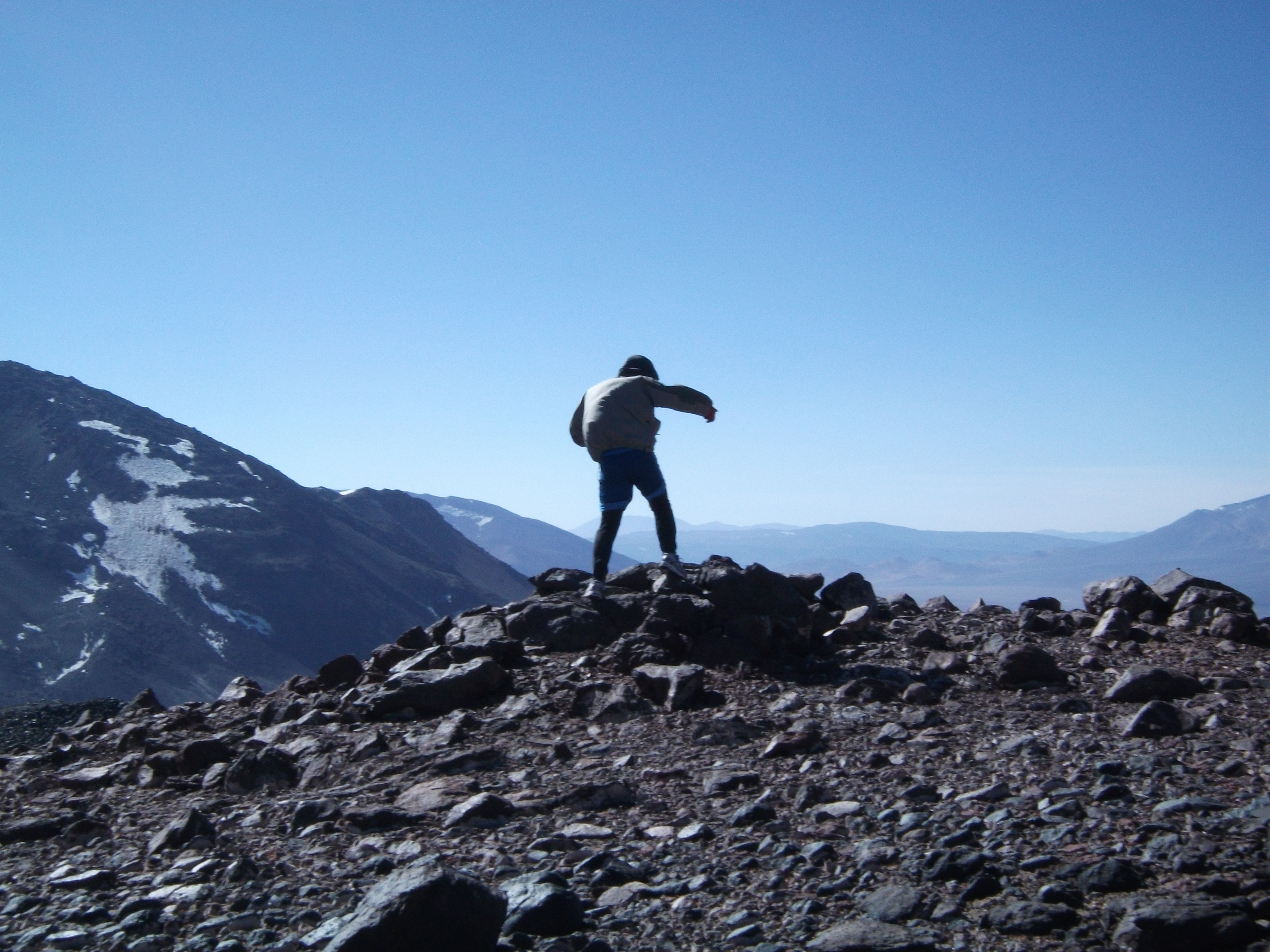
From the Argentine-Chilean border, Chandler and I pushed on. Now in the lee of Incahuasi, we entered a shallow crease between the volcano and a ridge, each of our footprints preserved in the sandy terrain as if it were a first snow. The landscape was timeless and still. We felt tired, even just a few hours in. Our backpacks, each about 65 pounds, felt every bit as much, and each breath of air was subtly unsatisfying. But we were making progress; Chandler and I had assimilated into the silence around us, but I felt an unspoken confidence between us. We could do this.
A few kilometers farther we were rewarded with an expansive vista. Ojos and its volcanic brethren crowded the horizon tens of kilometers ahead, and a yawning desert plain extended in between. We set off across it, hugging the base of an adjacent volcano, El Fraile, for on our other side was the vague region where Cristian had waved his hand—the minefield.
By dusk we had crossed the plain and entered the foothills buffering Ojos. We hadn’t seen evidence of another human all day: no footprints, no trash, no wind walls of campsites past, no airplanes, and, mercifully, no land mines. The tentacles of civilization’s inexorable advance had not yet reached this far.
Chandler and I had chosen an unconventional approach to Ojos. As opposed to the well-known ruta argentina or ruta chilena, we were improvising a ruta argentina-chilena, weaving illegally back and forth and back again over the border all the way to Ojos and its high camp. A mixture of motivations, most strategic and logistical, inspired the route. But one was very much aesthetic. This was very remote territory, even for the Puna, and we wanted the real frontier, a road never traveled.
Our camp that night rewarded those aspirations. We had chosen a spot nestled between two volcanoes. On one side rose El Fraile, its mammoth, rocky profile looming large above camp, catching the evening alpenglow like a giant textured canvas. As if to ward off ambitious climbers from its summit, Fraile wore a crown of treacherous-looking lava, and while I waited for cooking water to boil, I tried to pick out a route to the peak that managed to avoid its hazards.
On the other side of camp, however, was something even more alluring: El Muertito,“The Little Death,” a never-before-climbed volcano.
Its ominous name conjures menacing imagery, but El Muertito is essentially an incongruous lump of decaying volcanic rock, a decidedly non-technical climb and an ugly duckling to the pleasingly symmetrical, imposing image of its neighbor, El Fraile.
Were it not for the absence of snow, the eroding volcano could have been mistaken for a New England ski hill. But as we paced ourselves on El Muertito’s rocky scree, it wasn’t so much the mountain that was cause for our simmering excitement as it was what the mountain stood for. This was the notion of frontier distilled in a pithy, one-mountain manifestation. That it took the form of a New England ski hill was no obstacle to our sense of exploration.
The summit itself, an unassuming jumble of rocks, was nothing special. But as John Biggar, author of “The Andes,” the canonical guidebook for the cordillera, later informed us, we were standing on top of the highest unclimbed mountain in the Western Hemisphere. It felt great, as summits always do, and this one just a little bit more so.
The view was breathtaking. From our 5,985-meter perch, Ojos still dominated the south, but with our lofty spirits, it now began to look manageable. From our topographic map, Chandler and I could tell a crater resided inside El Muertito. At the summit, our suspicion was confirmed. And as it happened, at the center of the crater was a lake. A blood-red lake.

There are two theories behind its otherworldly beet red color. The first is that the color comes from purely mineral processes, namely iron cycling. The second theory is that microbes mediate oxidation in the acidic pool. According to Cara Santelli, a research geologist at the Smithsonian Institution, “If there is microbial life, it would be a great analog to studying life on other planets.”
We knew as soon as we saw the lake that this was a tremendously exciting discovery, if not scientifically, then personally. Several months after the fact, just thinking about it continues to give me a thrill.
This concept of discovery is fundamentally selfish. Anything that comes into the irreversible possession of one is forever denied to the rest; such is the cruel, inescapable paradox of frontiers. In a way, discovery is as much an elegy, for the thing discovered can never be discovered again.
Others have made this observation before. Upon the announcement of George Mallory’s inaugural expedition to Everest, the last great frontier of its era, London’s Evening News editorialized, “Some of the last mystery in the world will pass when the last secret place in it, the naked peak of Everest, shall be trodden by those trespassers.”
***
Two days later, the excitement of El Muertito and its mysterious lake had subsided, replaced instead by gnawing anxiety. Chandler and I were now at the Ojos high camp, our tent pitched in the shadow of a large boulder of lava, the mountain out of sight but very much in mind. This was a scheduled day of rest, “the most relaxing in years” for Chandler. For me, although I didn’t express it at the time, it was somewhat the opposite.
The foreign landscape impressed a feeling of just how out of place we were. This was my undoing four years ago as an 18-year-old. Alone, not far from where we were, with 11 days worth of food, set on summiting Ojos, I had instead abruptly turned around in retreat. Nine days of relatively uninterrupted solitude—consummate, consuming solitude, as I had never before known it—had deeply unsettled me. As I then wrote in my journal, this area, the ultra altiplano above 18,000 feet, was another kind of frontier:
…there is a jarring absence of other life. There are no vicuñas or guanacos [llamalike animals that live as high as 15,000 feet]; no birds in the sky, even if just migrating; no vermin; no shrubs, lichens, or mosses; no insects, not even ones blown astray by the terrain-scouring winds; not even the wee little ice worms eke out a humbled existence here. Everything is dead, and the zone of deadness expands for kilometer upon profound kilometer. This is obviously not intended habitat for humans, physically or psychologically…
Our relationship with other forms of life is only realized when we are without it. Watching the flora and fauna disappear species by species with each rung of altitude was unsettling. Few places create such a biological vacuum: the coldest wastelands, the driest deserts, the highest mountains. These frontiers of ultimate solitude seldom receive the lonesome visitor. Now, four years later, in Chandler I counted the best antidote to ultimate solitude I could imagine.
***
Summit morning, 3:30 a.m., we woke. It was cold. The beams of our flashlights jerked around the tent as we fumbled to put on our down parkas, mittens, and other insulation. We scarfed down a warm breakfast and set off into the inky blackness towards an invisible mountain.
The sun peered over the horizon five hours later, bringing earnestly appreciated light and warmth. When we turned around to inspect our progress, the landscape of the Puna ran away from us, its solemn volcanic reds and blacks interrupted occasionally by the cheerful piebald white of snowfields. But progress itself was too little, too slow.
I was the problem. Chandler and I both run competitively and enjoy enterprises of endurance; we normally make good time on mountains. But something serious was amiss.
The culprit, as my urine revealed, was dehydration. Dehydration is bad; extreme exertion while severely dehydrated at elevations above 18,000 feet is disastrous. By then, six hours in, my fatigue was expressing itself as a compelling desire to fall asleep right there on the mountain. The once-unthinkable notion of turning around before the summit began to snake its way through my synapses, gaining plausibility as it went. We paused for a two-hour break, to salvage a rapidly deteriorating situation. With Chandler fetching water from a nearby crater lake, reputed to be the highest standing body of water in the world, I rehydrated through two and a half liters of sips. As the fluids percolated through my system a faint but explicit sensation of strength returned.
Progress ensued, but our pace soon again slowed. Dehydration had fully drained my reservoir of energy. During our overwhelmingly frequent rest breaks, I would close my eyes, thoughts skittering about helter skelter, as if on ball bearings and free of cognitive friction. In a frontier of ultimate solitude, my condition might have been cause for concern, but with the resolute friendship and companionship of Chandler, I pressed on.
BY THE NUMBERS JONATHAN’S JOURNEY:
100 Kilometers traveled
600K number of steps taken by Chandler and Jonathan
$30K Cost of GPS equipment used
2 cm Margin of error for final GPS data
43% Air density at summit of Ojos relative to sea level
1 number of red crater lakes discovered
We passed a decades-old wreck of a high-altitude helicopter and rounded on to the Argentine summit of Ojos. That was it. A four-year personal journey, culminated. I lay down and closed my eyes.
***
Chandler took care of most of the rest, venturing across the rarely attempted and very exposed traverse to the Chilean summit. Over an hour later, he returned, we packed the GPS devices up, and began the return journey to camp. I was in a fatigued trance. Gray clouds swirled as we descended, enveloping where we once were, and a light snow began to fall. As dusk approached, finally, the garish orange of our tent appeared ahead. For me, it was food and sleep, deep and dreamless.
Chandler later told me he stayed awake for hours that night, worried my extreme fatigue might have been the initial symptoms of cerebral edema, a sometimes fatal condition brought on by altitude. Fortunately, it was not, and we hiked out the following days without incident. But that day, summit day on Ojos, the culmination of our trip and my four-year journey, was the hardest thing I’d ever put myself through, a statement not without competing precedent.

I had found my frontier, and it had kicked my butt.
On April 15, 2011, I received from UNAVCO final data from our GPS measurements. With a margin of error of two centimeters, about the width of two fingernails, the eastern or “de facto Argentine” summit is 31 centimeters taller than the western or “de facto Chilean” summit.
Jonathan Kreiss-Tomkins ’12 is a Political Science major in Branford College. Contact him at jonathan.kreiss-tomkins@yale.edu.